Cyclone Vaianu: MetService Issues Red Warnings, States of Emergency Declared Across North Island
MetService has placed Coromandel Peninsula, Bay of Plenty and Great Barrier Island under rare Red strong-wind warnings as former Cyclone Vaianu moves south over New Zealand. Local states of emergency are in force in Hawke's Bay, Whakatane and Waikato, with coastal evacuations already underway.
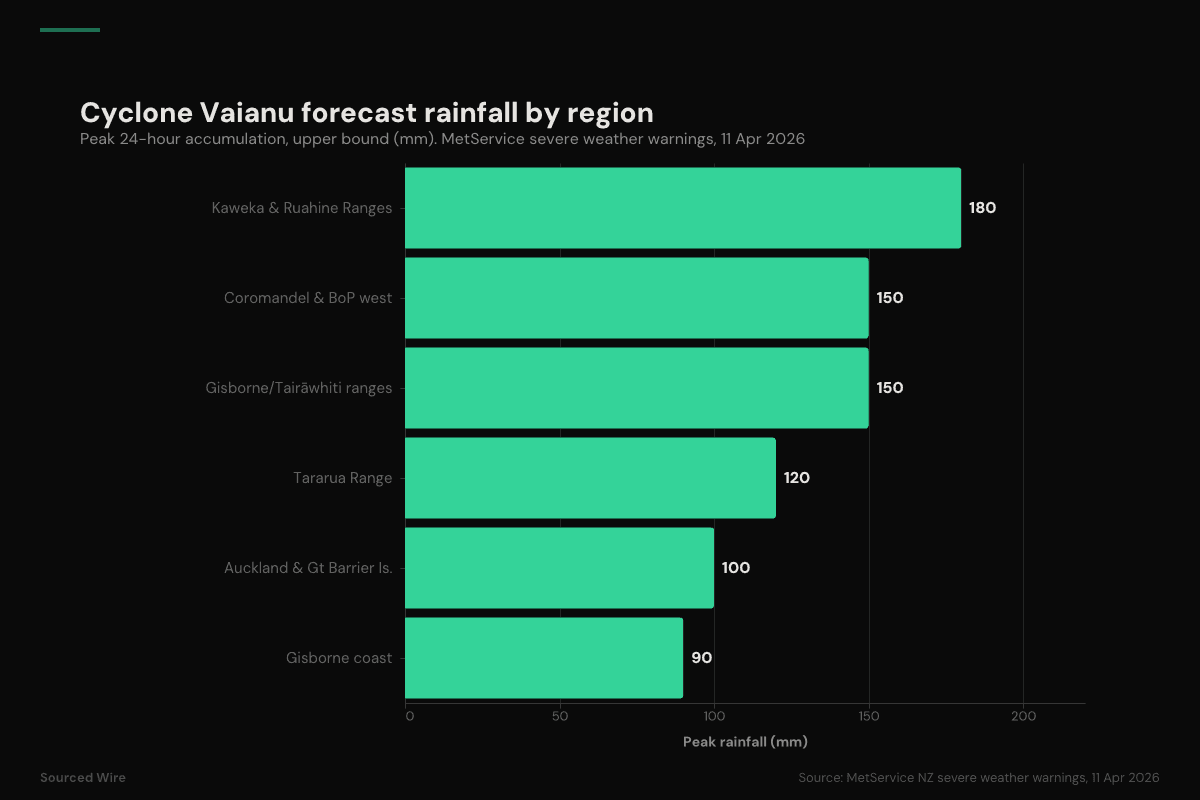
New Zealand's national weather service has issued Red strong-wind warnings — its most severe category — for Coromandel Peninsula, Bay of Plenty and Great Barrier Island as former Tropical Cyclone Vaianu moves south over the North Island. In its severe weather bulletin published on the morning of Saturday, April 11, MetService described the event as "a multi-hazard, potentially life-threatening" combination of damaging winds, heavy rain and coastal inundation, forecasting damaging gusts of 130 km/h in exposed places and rainfall totals of up to 180 mm across inland ranges.
Local states of emergency were declared during the day in Hawke's Bay, Whakatane and Waikato. The Hawke's Bay Civil Defence Emergency Management Group signed its declaration at 11:56 a.m., covering coastal areas of Napier, Hastings and Central Hawke's Bay. Hastings District Council issued evacuation orders for Haumoana, Te Awanga, Waimārama and Waipuka-Ocean Beach, telling residents in the mapped streets: "Now. Do not wait. Leaving early is safer."
What MetService is forecasting
The April 11 severe weather bulletin lists concurrent Red wind warnings, Orange rain warnings, and multiple watches. The Red warnings are the key escalation: MetService only issues a Red when it expects severe impacts including threat to life, widespread damage and disruption to transport and power. The service's public guidance for a Red wind warning is: "Stay indoors or seek sturdy shelter away from trees. Avoid travel. Be ready for power and communication outages."
Key forecast parameters from the bulletin:
| Region | Warning | Period | Forecast |
|---|---|---|---|
| Coromandel Peninsula, Great Barrier Island | Red strong wind | 10pm Sat – 8pm Sun | Severe gale easterlies backing northwest; gusts 130 km/h |
| Bay of Plenty, Rotorua | Red strong wind | 4am – 8pm Sun | Severe gale easterlies; gusts 130 km/h |
| Auckland, Great Barrier Island | Orange heavy rain | 9pm Sat – 2pm Sun | 70–100 mm, peaks 15–25 mm/h |
| Coromandel, western BoP, Rotorua | Orange heavy rain | 11pm Sat – 4pm Sun | 120–150 mm, peaks 25–40 mm/h |
| Gisborne/Tairāwhiti ranges | Orange heavy rain | 2am – 4pm Sun | 120–150 mm, peaks 25–40 mm/h |
| Kaweka & Ruahine Ranges |
The Kaweka and Ruahine Ranges, which sit above the Hawke's Bay coastal plains, are the highest-risk area for further escalation: MetService assigned a "moderate" chance of upgrading that warning to Red.
The storm's status
Vaianu is no longer a tropical cyclone in the technical sense. MetService's 10:48am tropical cyclone bulletin describes it as "Former Tropical Cyclone Vaianu… a significant sub-tropical system" moving southwards, expected to pass west of the Chatham Islands on Monday before tracking away to the southeast. Vaianu earlier affected Fiji and Tonga as a Category 3 severe tropical cyclone with 10-minute sustained winds of around 130 km/h before accelerating south into the Wellington Tropical Cyclone Warning Centre's area of responsibility.
The loss of tropical classification does not reduce its impact on land. MetService has placed the entire North Island under some level of strong-wind warning or watch for Sunday, April 12 — the first time it has done so — because the sub-tropical system is forecast to retain hurricane-force core winds and dump rain on ranges that feed into already-sensitive Hawke's Bay catchments.
Where it stands tonight
Late Saturday local time, the Hastings evacuation zones were active, Civil Defence Centres had opened (including Hastings Sports Centre on Railway Road, and the marae in Waimārama), and residents were being told to bring medication, documents, phones and pets. The Hastings District Council's standing line to anyone unsure whether they are in an evacuation zone is: "check the map carefully, ask Police or staff in your area. If you feel unsafe, leave early." The next MetService tropical cyclone bulletin is scheduled for noon Sunday, by which point Vaianu is forecast to be tracking across central parts of the North Island.