Forecasters split on 2026 hurricane season as El Nino battles record ocean heat
CSU and TSR predict a quiet Atlantic season suppressed by El Nino. The University of Arizona predicts 20 named storms, arguing warm ocean temperatures will override it -- exactly what happened in 2023.
Four major forecasting groups have weighed in on the 2026 Atlantic hurricane season, and they cannot agree. Colorado State University and Tropical Storm Risk predict a quiet year suppressed by El Nino. The University of Arizona predicts one of the most active seasons in recent memory, arguing that ocean temperatures are warm enough to overwhelm El Nino's dampening effect.
The gap between the lowest and highest forecasts -- 12 to 20 named storms -- is the widest early-season spread in over a decade.
The Forecasts
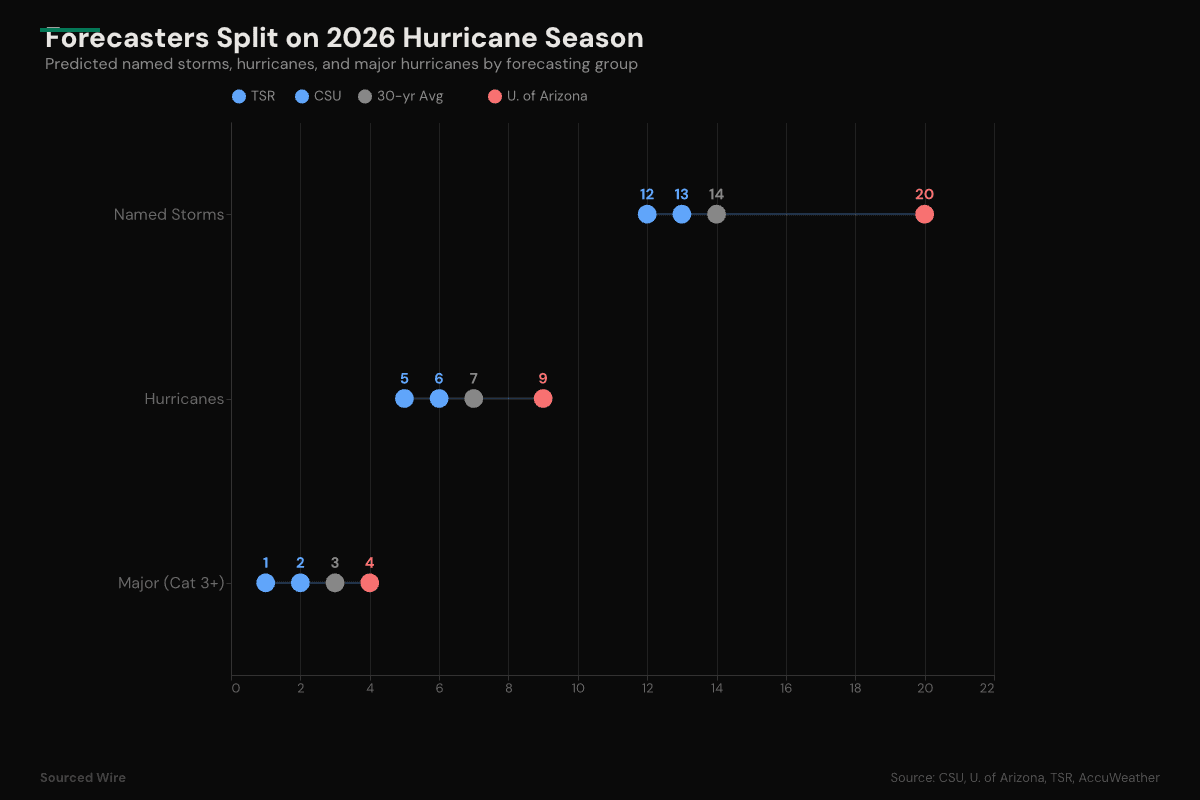
| Forecaster | Date | Named Storms | Hurricanes | Major (Cat 3+) | ACE |
|---|---|---|---|---|---|
| TSR | Apr 9 | 12 | 5 | 1 | 66 |
| CSU | Apr 9 | 13 | 6 | 2 | 90 |
| AccuWeather | Mar 25 | 11-16 | 4-7 | 2-4 | -- |
| U. of Arizona | Apr 7 | 20 | 9 | 4 |
CSU's forecast, released today, calls for 13 named storms, 6 hurricanes, and 2 major hurricanes -- all below the 30-year average. TSR's updated April forecast is even more subdued: 12 named storms, 5 hurricanes, and just 1 major hurricane, with an Accumulated Cyclone Energy index of 66 that would rank among the lowest in recent decades.
The University of Arizona is the outlier. Researchers Kyle Davis and Xubin Zeng project 20 named storms, 9 hurricanes, and 4 major hurricanes -- a season well above average. They call their own forecast "surprising" given the strength of the El Nino they expect.
The Split
The disagreement comes down to a single question: can record-warm Atlantic waters override El Nino?
NOAA projects an 80 percent chance of El Nino conditions during the peak hurricane months of August through October. El Nino strengthens upper-level winds across the tropical Atlantic, creating vertical wind shear that tears developing storms apart before they can organize. CSU expects wind shear across the tropical Atlantic to be the second highest since 1981, trailing only 2015 -- which produced just 11 named storms, the fewest in a decade.
Davis and Zeng see it differently. Their hybrid model -- combining European weather center dynamics with machine learning trained on 45 years of historical data -- points to Atlantic sea surface temperatures warm enough to cancel El Nino's suppressive effect. Some models indicate a possible "Super El Nino" with water temperatures more than 2 degrees Celsius above average in the key Nino 3.4 region. Yet they still forecast an active season.
AccuWeather splits the difference at 11 to 16 named storms, noting a 15 percent chance of a Super El Nino that would suppress activity further.
The 2023 Precedent
The last time forecasters faced this exact question was 2023. El Nino was strong. Atlantic waters were the warmest on record. CSU's initial April forecast that year called for 13 named storms -- below average. The season delivered 20, with three major hurricanes. The warm ocean won.
The University of Arizona's forecast explicitly draws on this precedent, noting that the 2026 sea surface temperature outlook remains only marginally lower than 2023's record levels.
The 2026 setup is not identical -- the El Nino now forming may be stronger than 2023's. But the fundamental question is the same: which signal dominates?
What This Means
The spread matters beyond meteorology. Insurance markets, offshore energy operations, and state emergency management agencies make planning and pricing decisions based on these outlooks. A 12-storm season and a 20-storm season demand very different levels of preparation and carry very different costs.
NOAA will release its official forecast in late May, typically the benchmark that drives federal and state planning. Until then, the data offers an honest answer: the ocean and the atmosphere are sending opposite signals, and the models disagree on which one wins.