CSU Forecasts Quietest Hurricane Season Since 2019 as El Nino Builds Toward Possible Super Event
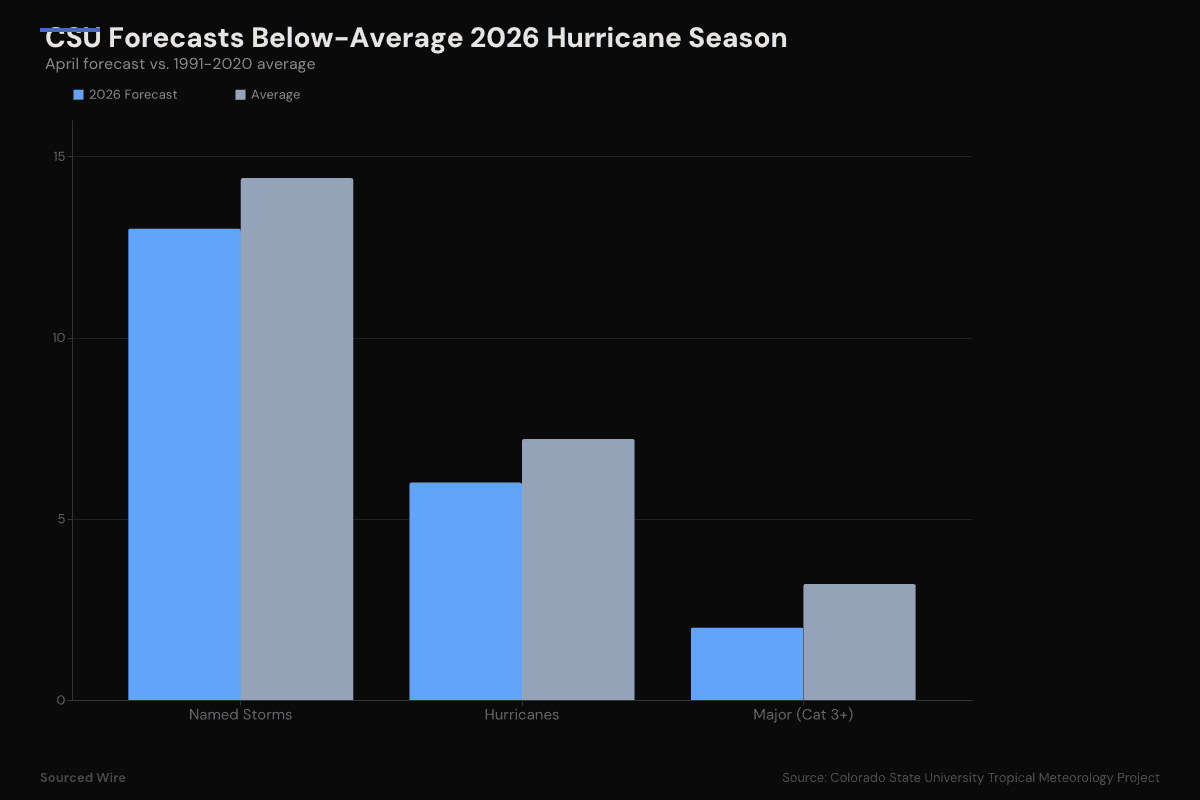
Colorado State University's first 2026 Atlantic forecast calls for 13 named storms and 2 major hurricanes -- below the 1991-2020 average on every metric -- as a strengthening El Nino is expected to shear apart developing storms across the tropical Atlantic.
Colorado State University released its first seasonal hurricane forecast for 2026 on Wednesday, calling for a below-average Atlantic season driven by what could become a strong or "super" El Nino by peak hurricane months.
The forecast -- the earliest CSU issues each year, and the first to incorporate an AI-based climate model -- projects 13 named storms, 6 hurricanes, and 2 major hurricanes (Category 3-4-5). Every metric falls below the 1991-2020 average. It is the fewest storms CSU has forecast since 2019.
The Numbers
| Parameter | 2026 Forecast | Average (1991-2020) |
|---|---|---|
| Named Storms | 13 | 14.4 |
| Named Storm Days | 55 | 69.4 |
| Hurricanes | 6 | 7.2 |
| Hurricane Days | 20 | 27.0 |
| Major Hurricanes (Cat 3+) | 2 | 3.2 |
| Major Hurricane Days | 5 | 7.4 |
| Accumulated Cyclone Energy | 90 | 123 |
| Net Tropical Cyclone Activity | 100 |
Overall Atlantic basin ACE and NTC activity are forecast at approximately 75% of their long-term averages.
Why El Nino Matters
The tropical Pacific is currently in weak La Nina conditions, transitioning toward neutral. CSU expects El Nino to develop in the coming months, potentially reaching moderate to strong intensity by the August-October peak of hurricane season. NOAA's Climate Prediction Center puts the probability of El Nino developing by June at 61%.
El Nino's effect on Atlantic hurricanes is well-established and mechanical: it increases vertical wind shear across the tropical Atlantic and Caribbean. Wind shear -- changes in wind speed or direction at different altitudes -- tilts and tears apart developing tropical systems before they can organize into hurricanes. CSU anticipates tropical Atlantic wind shear will be the second highest since 1981, trailing only 2015.
Sea surface temperatures complicate the picture. The western tropical Atlantic is warmer than normal -- a factor that typically fuels storms. But the eastern and central tropical Atlantic, where many hurricanes originate, is slightly cooler than normal. CSU expects El Nino to override the warm western waters as the dominant factor.
Landfall Probabilities
CSU estimates the probability of at least one major hurricane (Category 3-4-5) making landfall on U.S. soil at 32%, compared to a historical average of 43%.
| Region | 2026 Probability | Historical Average (1880-2020) |
|---|---|---|
| Entire U.S. coastline | 32% | 43% |
| East Coast incl. Peninsula Florida | 15% | 21% |
| Gulf Coast | 20% | 27% |
| Caribbean | 35% | 47% |
Every region is below its long-term average. But the CSU team emphasizes the oldest lesson in hurricane forecasting: "It only takes one hurricane making landfall to make it an active season."
What's New: AI Enters the Forecast
For the first time in CSU's 42-year forecasting history, the team incorporated output from the Ai2 Climate Emulator -- a machine learning-based climate model developed by the Allen Institute for AI. The AI model's guidance aligns with the statistical and dynamical models: a somewhat below-normal season.
The forecast also draws on ~40 years of statistical data, analog predictors, and dynamical model output from the European Centre for Medium Range Weather Forecasts, the UK Met Office, and the Centro Euro-Mediterraneo sui Cambiamenti Climatici.
Context
The 2026 forecast marks a sharp departure from the hyperactive stretch that has characterized recent Atlantic seasons. The 2025 season, driven by La Nina and record-warm sea surface temperatures, saw well-above-average activity. If El Nino develops as expected, 2026 would be a return to the suppressed pattern last seen during the strong El Nino of 2015-2016.
NOAA will release its official 2026 hurricane season outlook in May. CSU will update this forecast on June 4 and July 9 as atmospheric conditions become clearer.