M7.4 Earthquake Off Indonesia's Ternate Triggers Tsunami Waves at Five Coastal Stations
A shallow thrust earthquake in the Molucca Sea on April 1 generated tsunami waves up to 0.75m observed by BMKG, followed by a M6.2 aftershock and at least 77 smaller tremors in the nine days since.
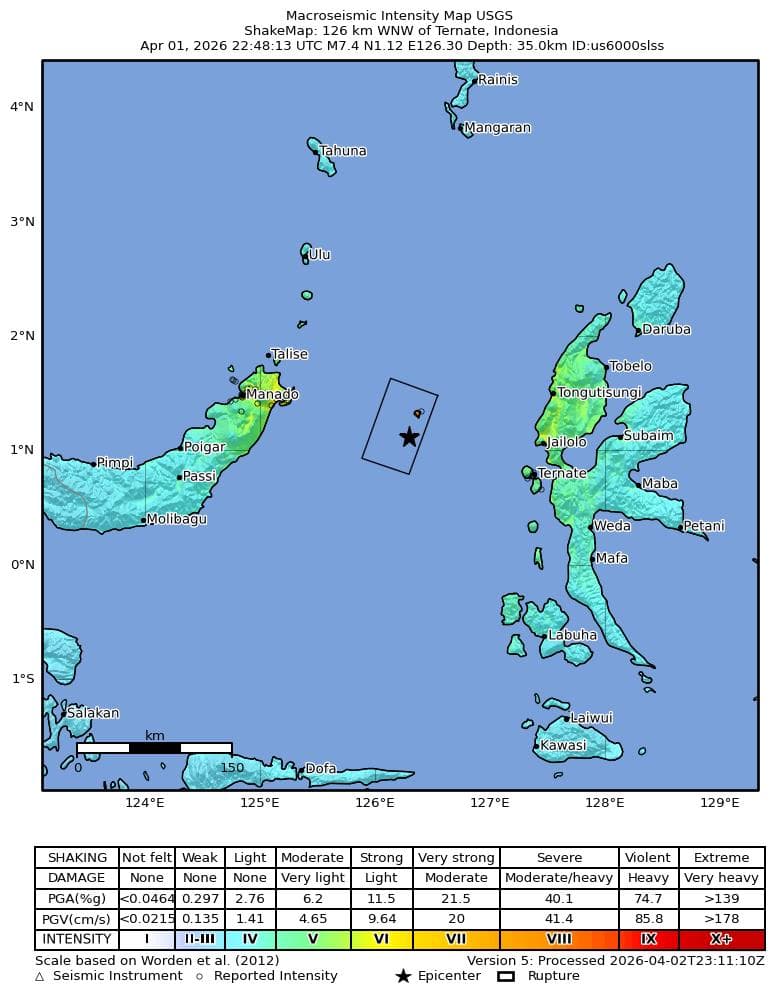
A magnitude 7.4 earthquake struck the Molucca Sea at 22:48:13 UTC on April 1, 2026 (05:48 WIB on April 2 local time), the USGS reports. The epicenter was 126 km west-northwest of Ternate at 1.1171°N, 126.2965°E, at a depth of 35 km. Indonesia's geophysical agency BMKG recorded the event at M7.6 using its own network and placed the epicenter slightly north at 1.25°N, 126.27°E at 33 km depth.
BMKG issued a tsunami warning within minutes and its InaTEWS tide gauges subsequently recorded waves at five coastal stations across North Sulawesi and Halmahera:
| Station | Time (WIB) | Wave height |
|---|---|---|
| West Halmahera | 06:08 | 0.30 m |
| Bitung | 06:15 | 0.20 m |
| Sidangoli | 06:16 | 0.35 m |
| North Minahasa | 06:18 | 0.75 m |
| Belang | 06:36 | 0.68 m |
The warning was lifted roughly two hours after the quake. The Pacific Tsunami Warning Center had initially flagged hazardous tsunami potential within 1,000 km of the epicenter for coastal Indonesia, the Philippines, and Malaysia.
Shaking and mechanism
BMKG classified the event as a shallow thrust rupture caused by crustal deformation, consistent with the Molucca Sea collision zone where the Sangihe and Halmahera microplates are converging. USGS ShakeMap modeling gave a maximum instrumental intensity of MMI VIII ("severe") near the epicenter, with "Did You Feel It" citizen reports reaching 9.1 in the Ternate and North Sulawesi coastal zone.
Despite the severe shaking near the source, the USGS PAGER automated impact model issued a green alert, indicating low expected fatalities and limited economic losses, largely because the rupture occurred offshore with its strongest shaking directed over water.
Aftershock sequence
A M6.2 aftershock struck the same region at 03:23 UTC on April 2, about four and a half hours after the mainshock, 113 km west-northwest of Ternate. Between April 1 and April 10, USGS catalogued 79 earthquakes of M4.0 or greater within 200 km of the mainshock epicenter, including 27 events of M5.0 or greater.
Regional context
The Molucca Sea is one of the world's only places where two oceanic subduction zones collide head-on, making it among Indonesia's most seismically active regions. The last comparable event in the immediate area was a M7.1 earthquake in July 2019 that caused a small tsunami in the Sula Islands.